
Arenas topographic map
Interactive map
Click on the map to display elevation.
About this map
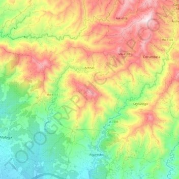
Name: Arenas topographic map, elevation, terrain.
Location: Arenas, La Axarquía, Malaga, Andalusia, Spain (36.77277 -4.12733 36.83784 -4.01724)
Average elevation: 1,158 ft
Minimum elevation: 59 ft
Maximum elevation: 2,533 ft
Arenas's urban landscape is typically Andalusian with narrow streets, steep and with whitewashed buildings. It is surrounded by mountains very close to the Mediterranean Sea. Mount Bentomiz has an altitude of 711 m in altitude, steep slopes and with views over the coast and the region of Axarquia. Other mountains are Cerro Beas and Cerro Alto. Arenas shares with Canillas de Aceituno, Sedella, and Salares a large area in the Sierras of Tejeda, Almijara and Alhama Natural Park. Several trails, gorges, and streams allow for hiking and climbing.
Other topographic maps
Click on a map to view its topography, its elevation and its terrain.
Riogordo
Spain > Andalusia > La Axarquía
Riogordo, La Axarquía, Malaga, Andalusia, 29180, Spain
Average elevation: 1,952 ft
Viñuela
Spain > Andalusia > La Axarquía
Viñuela, La Axarquía, Malaga, Andalusia, Spain
Average elevation: 1,024 ft
Arroyo
Spain > Andalusia > La Axarquía > Frigiliana
Arroyo, Frigiliana, La Axarquía, Malaga, Andalusia, 28788, Spain
Average elevation: 1,834 ft
Rincón de la Victoria
Spain > Andalusia > La Axarquía > Rincón de la Victoria
Rincón de la Victoria, La Axarquía, Malaga, Andalusia, Spain
Average elevation: 551 ft
Colmenar
Spain > Andalusia > La Axarquía > Colmenar
Colmenar, La Axarquía, Malaga, Andalusia, 29170, Spain
Average elevation: 2,369 ft
Comares
Spain > Andalusia > La Axarquía
Comares, La Axarquía, Malaga, Andalusia, 29195, Spain
Average elevation: 1,165 ft
Algarrobo
Spain > Andalusia > La Axarquía
Algarrobo, La Axarquía, Malaga, Andalusia, 29750, Spain
Average elevation: 436 ft
Nerja
Spain > Andalusia > La Axarquía
Nerja, La Axarquía, Malaga, Andalusia, Spain
Average elevation: 1,591 ft