
Make a donation
Gear up for your next adventure:
As an Amazon Associate, this site earns from qualifying purchases at no extra cost to you.
Ocejón topographic map
Click on the map to display elevation.
Make a donation
Gear up for your next adventure:
As an Amazon Associate, this site earns from qualifying purchases at no extra cost to you.
Ocejón
Es el pico principal de la parte más meridional de la sierra de Ayllón, constituyendo, con sus 2049 m, la máxima elevación de la sierra del Ocejón o del Robledal, donde ocupa una situación meridional, extendiéndose este desde el propio pico Ocejón hacia el norte. Es una montaña constituida por piedra de pizarra y formada por plegamiento. Así, por su forma de pliegue es anticlinal y asimétrico, por su inclinación es recto, por el espesor de sus capas es anisópaco y sus flancos son suaves.
Make a donation
Gear up for your next adventure:
As an Amazon Associate, this site earns from qualifying purchases at no extra cost to you.
About this map
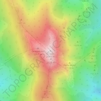
Name: Ocejón topographic map, elevation, terrain.
Average elevation: 5,354 ft
Minimum elevation: 4,180 ft
Maximum elevation: 6,696 ft
Make a donation
Gear up for your next adventure:
As an Amazon Associate, this site earns from qualifying purchases at no extra cost to you.