
Make a donation
Gear up for your next adventure:
As an Amazon Associate, this site earns from qualifying purchases at no extra cost to you.
Parque Natural Sierra de Irta topographic map
Click on the map to display elevation.
Make a donation
Gear up for your next adventure:
As an Amazon Associate, this site earns from qualifying purchases at no extra cost to you.
Parque Natural Sierra de Irta
El parque natural está formado por dos alineaciones montañosas con una altitud máxima de 572 metros (el pico Campanilles) paralelas a la costa y separadas por el valle de Estopet.
Make a donation
Gear up for your next adventure:
As an Amazon Associate, this site earns from qualifying purchases at no extra cost to you.
About this map
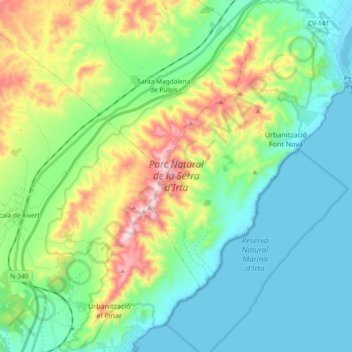
Name: Parque Natural Sierra de Irta topographic map, elevation, terrain.
Average elevation: 499 ft
Minimum elevation: -3 ft
Maximum elevation: 1,814 ft
Make a donation
Gear up for your next adventure:
As an Amazon Associate, this site earns from qualifying purchases at no extra cost to you.
Other topographic maps
Click on a map to view its topography, its elevation and its terrain.