
Make a donation
Gear up for your next adventure:
As an Amazon Associate, this site earns from qualifying purchases at no extra cost to you.
Duanesburg topographic map
Click on the map to display elevation.
Make a donation
Gear up for your next adventure:
As an Amazon Associate, this site earns from qualifying purchases at no extra cost to you.
Duanesburg
The town consists of mostly wooded hills up to an elevation of approximately 1,400 feet (430 m) above sea level. Most of the town was cleared farmland until the late 20th century. After this point forests grew to cover 60% of the total land area with a canopy higher than 40 feet (12 m). The forest is primary composed of poplar, hemlock, oak, maple, white pine, and balsam fir. The maximum tree heights in Duanesburg are approximately 80 feet (24 m) high.
Make a donation
Gear up for your next adventure:
As an Amazon Associate, this site earns from qualifying purchases at no extra cost to you.
About this map
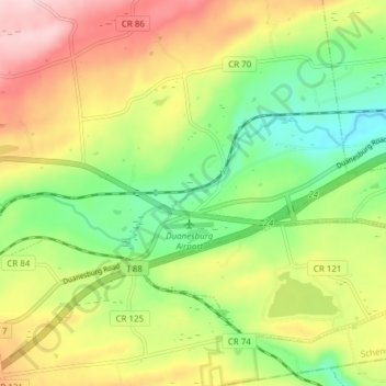
Name: Duanesburg topographic map, elevation, terrain.
Average elevation: 876 ft
Minimum elevation: 505 ft
Maximum elevation: 1,345 ft
Schenectady County trails, hiking, mountain biking, running and outdoor activities
Make a donation
Gear up for your next adventure:
As an Amazon Associate, this site earns from qualifying purchases at no extra cost to you.