

Mutare topographic map
Click on the map to display elevation.
Mutare
Despite its subtropical location, the city has a humid subtropical climate, of the highland variety moderated by its altitude. The average annual temperature is 19 °C, surprisingly low for its moderate altitude (about the same as Harare which is 360 metres higher.) This is due to its sheltered position against the mountain ridge of Cecil Kop which encourages cool breezes from lower altitude to the east and south. The coldest month is July (minimum 6 °C and maximum 20 °C) and the hottest month is October (minimum 16 °C and maximum 32 °C). The annual rainfall is 818 mm. Rain falls mostly in the months December to February although heavy showers are possible before and after this period. The wettest month on record was January 1926 which received 580 mm while January 1991 received only 24 mm.
About this map
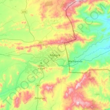
Name: Mutare topographic map, elevation, terrain.
Location: Mutare, Manicaland Province, Zimbabwe (-19.13466 32.51047 -18.81466 32.83047)
Average elevation: 3,806 ft
Minimum elevation: 2,359 ft
Maximum elevation: 6,230 ft