Geolocate

Menkor topographic map

Click on the map to display elevation.

About this map

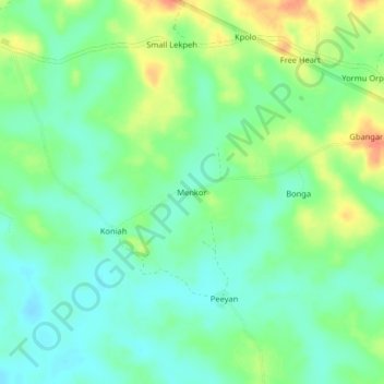
Name: Menkor topographic map, elevation, terrain.

Location: Menkor, Dowein, Bomi County, Liberia (6.58011 -10.98120 6.62011 -10.94120)

Average elevation: 75 ft

Minimum elevation: 20 ft

Maximum elevation: 171 ft

Gear up for your next adventure:

📚Navigation Handbooks - Master the art of reading topographic maps and using a compass
🛡️Insect Repellent - Protection against bugs during outdoor activities
🛰️Handheld GPS Units - Professional satellite navigators for precise backcountry mapping
🪶Compact Camp Shovel - Folding shovel for campsite tasks
🎒Hydration Pack - Hands‑free water reservoir for long hikes

As an Amazon Associate, this site earns from qualifying purchases at no extra cost to you.