
Fort Atkinson topographic map
Interactive map
Click on the map to display elevation.
About this map
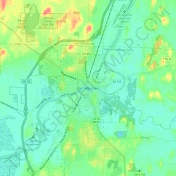
Name: Fort Atkinson topographic map, elevation, terrain.
Location: Fort Atkinson, Jefferson County, Wisconsin, United States (42.88824 -88.87377 42.96952 -88.80919)
Average elevation: 817 ft
Minimum elevation: 758 ft
Maximum elevation: 965 ft
Jefferson County trails, hiking, mountain biking, running and outdoor activities
Other topographic maps
Click on a map to view its topography, its elevation and its terrain.
Aztalan State Park
United States > Wisconsin > Jefferson County > Town of Aztalan
Average elevation: 837 ft