
Make a donation
Gear up for your next adventure:
As an Amazon Associate, this site earns from qualifying purchases at no extra cost to you.
Chepén topographic map
Click on the map to display elevation.
Make a donation
Gear up for your next adventure:
As an Amazon Associate, this site earns from qualifying purchases at no extra cost to you.
Chepén
El distrito ocupa una superficie de 287,34 km² a una altitud de 130 m s. n. m. Según el censo del año 2015 tiene una población de 48 563 habitantes.
Make a donation
Gear up for your next adventure:
As an Amazon Associate, this site earns from qualifying purchases at no extra cost to you.
About this map
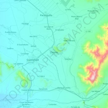
Name: Chepén topographic map, elevation, terrain.
Location: Chepén, La Libertad, Perú (-7.32524 -79.46850 -7.13901 -79.25180)
Average elevation: 594 ft
Minimum elevation: 102 ft
Maximum elevation: 4,334 ft
Make a donation
Gear up for your next adventure:
As an Amazon Associate, this site earns from qualifying purchases at no extra cost to you.
Other topographic maps
Click on a map to view its topography, its elevation and its terrain.
Make a donation
Gear up for your next adventure:
As an Amazon Associate, this site earns from qualifying purchases at no extra cost to you.
Make a donation
Gear up for your next adventure:
As an Amazon Associate, this site earns from qualifying purchases at no extra cost to you.