
Make a donation
Gear up for your next adventure:
As an Amazon Associate, this site earns from qualifying purchases at no extra cost to you.
Mezquital topographic map
Click on the map to display elevation.
Make a donation
Gear up for your next adventure:
As an Amazon Associate, this site earns from qualifying purchases at no extra cost to you.
About this map
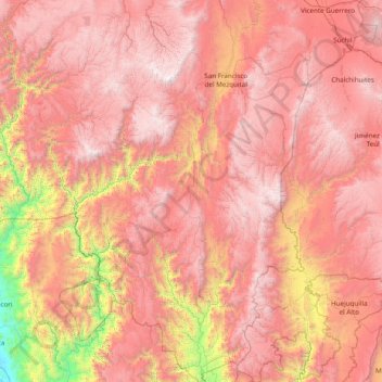
Name: Mezquital topographic map, elevation, terrain.
Location: Mezquital, Durango, Mexico (22.34508 -105.07237 23.76873 -104.08007)
Average elevation: 6,132 ft
Minimum elevation: 69 ft
Maximum elevation: 10,689 ft
Make a donation
Gear up for your next adventure:
As an Amazon Associate, this site earns from qualifying purchases at no extra cost to you.
Other topographic maps
Click on a map to view its topography, its elevation and its terrain.
Make a donation
Gear up for your next adventure:
As an Amazon Associate, this site earns from qualifying purchases at no extra cost to you.
Cienega de Nuestra Señora
Mexico > Durango > Santiago Papasquiaro > Cienega de Nuestra Señora
Average elevation: 8,501 ft
Make a donation
Gear up for your next adventure:
As an Amazon Associate, this site earns from qualifying purchases at no extra cost to you.