
Thank you for supporting this site ❤️
Make a donation
Make a donation
Gear up for your next adventure:
As an Amazon Associate, this site earns from qualifying purchases at no extra cost to you.
Santacruz topographic map
Click on the map to display elevation.
Thank you for supporting this site ❤️
Make a donation
Make a donation
Gear up for your next adventure:
As an Amazon Associate, this site earns from qualifying purchases at no extra cost to you.
About this map
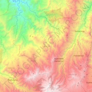
Name: Santacruz topographic map, elevation, terrain.
Location: Santacruz, Los Abades, Nariño, Colombia (1.09135 -77.86380 1.46395 -77.61243)
Average elevation: 6,873 ft
Minimum elevation: 1,060 ft
Maximum elevation: 12,963 ft
Thank you for supporting this site ❤️
Make a donation
Make a donation
Gear up for your next adventure:
As an Amazon Associate, this site earns from qualifying purchases at no extra cost to you.