
Make a donation
Gear up for your next adventure:
As an Amazon Associate, this site earns from qualifying purchases at no extra cost to you.
Yap topographic map
Click on the map to display elevation.
Make a donation
Gear up for your next adventure:
As an Amazon Associate, this site earns from qualifying purchases at no extra cost to you.
Yap
Yap is actually made up of four separate islands: Yap Proper (Marbaaq), Gagil-Tamil, Maap (Yapese: Maap′), and Rumung. The four islands are separated by relatively narrow water features, and the islands are surrounded by a common coral reef. Gagil-Tamil was once connected to Yap Proper, but a canal, Tagireeng Canal, less than 10 meters wide, was constructed that separated the two landmasses in 1901. Yap was formed from an uplift of the Philippine Sea Plate, and is referred to as a "high" island as opposed to atolls. The land is mostly rolling hills, with densely vegetated valleys and savanna interiors. Mangrove swamps line much of the shore, although there are beaches on the northern and western sides of the islands. Excluding the reef area, the Yap Main Islands are approximately 24 km long, 5–10 km wide, and 98 km2. The highest elevation is 178 m (584 ft) at Mount Taabiywol in Fanif municipality on Yap Proper.
Make a donation
Gear up for your next adventure:
As an Amazon Associate, this site earns from qualifying purchases at no extra cost to you.
About this map
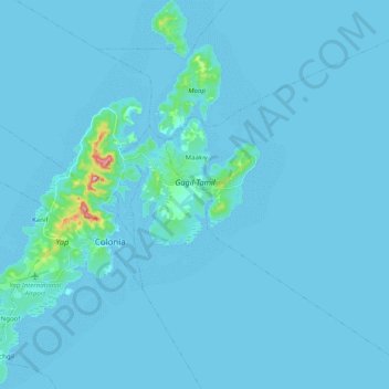
Name: Yap topographic map, elevation, terrain.
Location: Yap, Gagil, Yap, 96943, Federated States of Micronesia (9.44176 138.05495 9.63831 138.19848)
Average elevation: 20 ft
Minimum elevation: -3 ft
Maximum elevation: 577 ft
Make a donation
Gear up for your next adventure:
As an Amazon Associate, this site earns from qualifying purchases at no extra cost to you.