
Grebbeberg topographic map
Interactive map
Click on the map to display elevation.
About this map
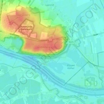
Name: Grebbeberg topographic map, elevation, terrain.
Location: Grebbeberg, Rhenen, Utrecht, Nederland, 3911AB, Nederland (51.95174 5.60084 51.95184 5.60094)
Average elevation: 49 ft
Minimum elevation: 3 ft
Maximum elevation: 164 ft
Other topographic maps
Click on a map to view its topography, its elevation and its terrain.
Grebbeberg
Grebbeberg, Heimersteinselaan, Rhenen, Utrecht, Nederland, 3911 AZ, Nederland
Average elevation: 52 ft
Uiterwaarden Neder-Rijn
Uiterwaarden Neder-Rijn, Rhenen, Utrecht, Nederland, 4021 AE, Nederland
Average elevation: 33 ft