
Durban topographic map
Click on the map to display elevation.
About this map
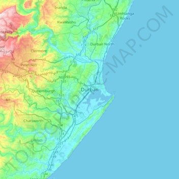
Name: Durban topographic map, elevation, terrain.
Average elevation: 272 ft
Minimum elevation: -3 ft
Maximum elevation: 1,969 ft
Other topographic maps
Click on a map to view its topography, its elevation and its terrain.
Inanda Dam
South Africa > KwaZulu-Natal > eThekwini Metropolitan Municipality
Average elevation: 728 ft
Umgeni River
South Africa > KwaZulu-Natal > eThekwini Metropolitan Municipality > Queensburgh
Average elevation: 430 ft
Pigeon Valley
South Africa > KwaZulu-Natal > eThekwini Metropolitan Municipality > Durban
Average elevation: 226 ft
uMngeni River
South Africa > KwaZulu-Natal > eThekwini Metropolitan Municipality
Average elevation: 1,962 ft
Umgeni River
South Africa > KwaZulu-Natal > eThekwini Metropolitan Municipality > Queensburgh
Average elevation: 509 ft
Molweni River
South Africa > KwaZulu-Natal > eThekwini Metropolitan Municipality > Forest Hills
Average elevation: 745 ft
Umbilo River
South Africa > KwaZulu-Natal > eThekwini Metropolitan Municipality > Durban
Average elevation: 184 ft
Bluff Nature Reserve
South Africa > KwaZulu-Natal > eThekwini Metropolitan Municipality > Durban
Average elevation: 125 ft
Umhlanga River
South Africa > KwaZulu-Natal > eThekwini Metropolitan Municipality > Phoenix
Average elevation: 427 ft
Umbilo River
South Africa > KwaZulu-Natal > eThekwini Metropolitan Municipality > Pinetown
Average elevation: 1,106 ft
Izinga Walkways
South Africa > KwaZulu-Natal > eThekwini Metropolitan Municipality > Umhlanga Rocks
Average elevation: 308 ft
Palmiet River
South Africa > KwaZulu-Natal > eThekwini Metropolitan Municipality > Pinetown
Average elevation: 1,010 ft
eThekwini Ward 32
South Africa > KwaZulu-Natal > eThekwini Metropolitan Municipality
Average elevation: 82 ft
Umgeni River
South Africa > KwaZulu-Natal > eThekwini Metropolitan Municipality > Queensburgh
Average elevation: 430 ft
Umbilo River
South Africa > KwaZulu-Natal > eThekwini Metropolitan Municipality > Durban
Average elevation: 184 ft
uMngeni River
South Africa > KwaZulu-Natal > eThekwini Metropolitan Municipality
Average elevation: 1,962 ft
Plantations
South Africa > KwaZulu-Natal > eThekwini Metropolitan Municipality > Hillcrest
Average elevation: 2,070 ft