
Westigerbach topographic map
Interactive map
Click on the map to display elevation.
About this map
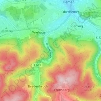
Name: Westigerbach topographic map, elevation, terrain.
Average elevation: 1,076 ft
Minimum elevation: 692 ft
Maximum elevation: 1,591 ft
Other topographic maps
Click on a map to view its topography, its elevation and its terrain.
Edelburg
Deutschland > Nordrhein-Westfalen > Märkischer Kreis > Hemer
Edelburg, Hemer, Märkischer Kreis, Nordrhein-Westfalen, 58706, Deutschland
Average elevation: 702 ft
Grüntal
Deutschland > Nordrhein-Westfalen > Märkischer Kreis > Hemer > Grüntal
Grüntal, Hemer, Märkischer Kreis, Nordrhein-Westfalen, 58675, Deutschland
Average elevation: 1,132 ft