Geolocate

Wymondham topographic map

Click on the map to display elevation.

Wymondham

Wymondham's topography is marked by its river meadow and flat, low-lying agricultural landscape, much like the rest of East Anglia. The parish has an area of 17.11 square miles (44.31 km2). The geology is based on chalk, with a layer of boulder clay laid down in the last ice age. The River Tiffey, flowing north, forms a boundary between the built-up town centre and the rural southern part of the parish.

Wikipedia (CC-BY-SA 3.0)

About this map

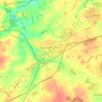
Name: Wymondham topographic map, elevation, terrain.

Location: Wymondham, South Norfolk, Norfolk, England, NR18, United Kingdom (52.53735 1.07661 52.61070 1.16459)

Average elevation: 141 ft

Minimum elevation: 46 ft

Maximum elevation: 213 ft

Other topographic maps

Click on a map to view its topography, its elevation and its terrain.

Welborne

United Kingdom > England > Norfolk > South Norfolk

Average elevation: 157 ft

Harleston

United Kingdom > England > Norfolk > South Norfolk

Average elevation: 121 ft

Morningthorpe

United Kingdom > England > Norfolk > South Norfolk

Average elevation: 151 ft

Morley St Peter

United Kingdom > England > Norfolk > South Norfolk

Average elevation: 157 ft

Thorpe Abbotts

United Kingdom > England > Norfolk > South Norfolk

Average elevation: 131 ft

Hapton

United Kingdom > England > Norfolk > South Norfolk

Average elevation: 121 ft

Kirby Row

United Kingdom > England > Norfolk > South Norfolk > Kirby Cane

Average elevation: 52 ft

Hethel

United Kingdom > England > Norfolk > South Norfolk

Average elevation: 154 ft

Sneath Common

United Kingdom > England > Norfolk > South Norfolk

Average elevation: 167 ft

Keswick

United Kingdom > England > Norfolk > South Norfolk

Average elevation: 75 ft

Tharston

United Kingdom > England > Norfolk > South Norfolk

Average elevation: 121 ft

Trowse

United Kingdom > England > Norfolk > South Norfolk

Average elevation: 75 ft

Marlingford

United Kingdom > England > Norfolk > South Norfolk

Average elevation: 112 ft

Chapel Hill

United Kingdom > England > Norfolk > South Norfolk

Average elevation: 59 ft

Lushbush

United Kingdom > England > Norfolk > South Norfolk > Harleston

Average elevation: 108 ft

Fersfield

United Kingdom > England > Norfolk > South Norfolk > Fersfield

Average elevation: 148 ft

Deopham Green

United Kingdom > England > Norfolk > South Norfolk > Deopham

Average elevation: 167 ft

Harleston

United Kingdom > England > Norfolk > South Norfolk

Average elevation: 121 ft

Thorpe Abbotts

United Kingdom > England > Norfolk > South Norfolk

Average elevation: 131 ft

Surlingham

United Kingdom > England > Norfolk > South Norfolk

Average elevation: 39 ft

Gear up for your next adventure:

🚑Emergency Bivvies - Heat-reflective sleeping bags for survival situations
📻Weather Alert Radios - Stay informed of storm risks while off-the-grid
🔦Compact Flashlight - Reliable flashlight for emergencies
👟Trail Running Shoes - Lightweight shoes for trail runners
🎁Geography Themed Gifts - Unique gift ideas for map lovers and geography enthusiasts

As an Amazon Associate, this site earns from qualifying purchases at no extra cost to you.