
Make a donation
Gear up for your next adventure:
As an Amazon Associate, this site earns from qualifying purchases at no extra cost to you.
Krusevac topographic map
Click on the map to display elevation.
Make a donation
Gear up for your next adventure:
As an Amazon Associate, this site earns from qualifying purchases at no extra cost to you.
About this map
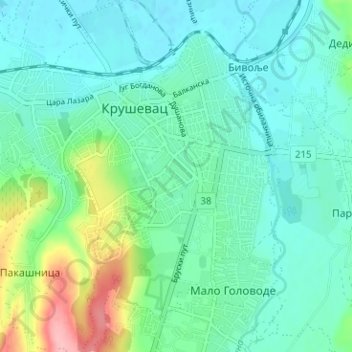
Name: Krusevac topographic map, elevation, terrain.
Average elevation: 558 ft
Minimum elevation: 466 ft
Maximum elevation: 873 ft
Make a donation
Gear up for your next adventure:
As an Amazon Associate, this site earns from qualifying purchases at no extra cost to you.
Other topographic maps
Click on a map to view its topography, its elevation and its terrain.
Jastrebac
Serbia > Central Serbia > Rasina Administrative District > Srndalje
Jastrebac (Serbian Cyrillic: Јастребац) is a mountain in central Serbia, between cities of Niš, Kruševac and Prokuplje. It consists of two massifs, Great (Veliki) and Small (Mali) Jastrebac. Its highest peak Velika Đulica has an elevation of 1,491 meters above sea level. It is well-forested and…
Average elevation: 3,858 ft
Јечмениште
Serbia > Central Serbia > Rasina Administrative District > Trstenik Municipality
Average elevation: 1,427 ft
Kopaonik
Serbia > Central Serbia > Rasina Administrative District > Brus Municipality
The national park is situated on a relatively flat region, at an altitude of about 1,700 m (5,577 ft). This central Kopaonik plateau is called Suvo Rudište. It is surrounded by mountain peaks. To the north and northwest of this plateau stretches Banjski Kopaonik, which is the location of Jošanička Banja…
Average elevation: 5,686 ft
Batote
Serbia > Central Serbia > Rasina Administrative District > Brus Municipality > Batote
Batote is located on the national highway NH 44 from Jammu to Srinagar at 33°06′N 75°19′E / 33.10°N 75.32°E / 33.10; 75.32. It has an average elevation of 1,555 metres (6,584 feet).
Average elevation: 2,388 ft
Make a donation
Gear up for your next adventure:
As an Amazon Associate, this site earns from qualifying purchases at no extra cost to you.
Karanovac
Serbia > Central Serbia > Rasina Administrative District > Varvarin Municipality > Karanovac
Average elevation: 1,007 ft
Veliki Vetren
Serbia > Central Serbia > Rasina Administrative District > Varvarin Municipality
Average elevation: 1,729 ft
Trstenik
Serbia > Central Serbia > Rasina Administrative District > Trstenik Municipality
Average elevation: 863 ft