
Ampthill topographic map
Click on the map to display elevation.
About this map
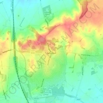
Name: Ampthill topographic map, elevation, terrain.
Location: Ampthill, Central Bedfordshire, England, United Kingdom (52.01602 -0.51835 52.04883 -0.46137)
Average elevation: 279 ft
Minimum elevation: 174 ft
Maximum elevation: 423 ft
Other topographic maps
Click on a map to view its topography, its elevation and its terrain.
Little Billington
United Kingdom > England > Central Bedfordshire > Great Billington > Little Billington
Average elevation: 302 ft
Redlodge Plantation
United Kingdom > England > Central Bedfordshire > Woburn
Average elevation: 400 ft