Geolocate

Marion topographic map

Click on the map to display elevation.

About this map

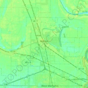
Name: Marion topographic map, elevation, terrain.

Location: Marion, Crittenden County, Arkansas, 72364, United States (35.15421 -90.28632 35.26296 -90.12616)

Average elevation: 220 ft

Minimum elevation: 197 ft

Maximum elevation: 243 ft

Crittenden County trails, hiking, mountain biking, running and outdoor activities

Other topographic maps

Click on a map to view its topography, its elevation and its terrain.

Julius

United States > Arkansas > Crittenden County

Average elevation: 217 ft

Hulbert

United States > Arkansas > Crittenden County > West Memphis

Average elevation: 213 ft

Proctor

United States > Arkansas > Crittenden County

Average elevation: 207 ft

Gear up for your next adventure:

🔭Stargazing Telescopes - Perfect for camping in low-light pollution areas shown on maps
🛡️Insect Repellent - Protection against bugs during outdoor activities
🩹Survival Bandages - High‑quality bandages for emergencies
🧦Merino Wool Socks - Moisture-wicking, blister-preventing socks for long treks
🧭Hiking Compass - Precision compass for reliable navigation in the wilderness

As an Amazon Associate, this site earns from qualifying purchases at no extra cost to you.