Geolocate

Whaddon topographic map

Click on the map to display elevation.

About this map

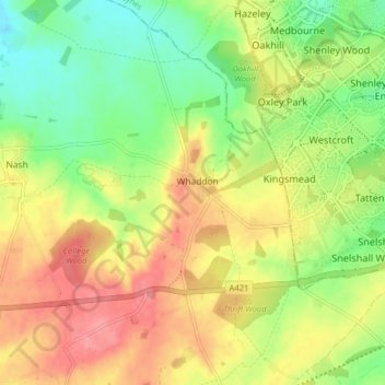
Name: Whaddon topographic map, elevation, terrain.

Location: Whaddon, Buckinghamshire, England, United Kingdom (51.97334 -0.85384 52.02236 -0.80353)

Average elevation: 374 ft

Minimum elevation: 243 ft

Maximum elevation: 512 ft

Other topographic maps

Click on a map to view its topography, its elevation and its terrain.

Bledlow Ridge

United Kingdom > England > Buckinghamshire

Average elevation: 525 ft

Burcott

United Kingdom > England > Buckinghamshire > Wing

Average elevation: 407 ft

Grove

United Kingdom > England > Buckinghamshire

Average elevation: 308 ft

Loudwater

United Kingdom > England > Buckinghamshire

Average elevation: 299 ft

Tylers Green

United Kingdom > England > Buckinghamshire

Average elevation: 492 ft

Haddington Hill

United Kingdom > England > Buckinghamshire > Halton

Average elevation: 682 ft

Gear up for your next adventure:

🏕️Family Camping Gear - Essentials for group camping trips
🧣Merino Neck Gaiters - Multi-functional headwear for wind and sun protection
🗃️Trail First Aid Kit - Essential kit for outdoor injuries and emergencies
🪑Ultralight Camp Chairs - Portable seating for resting after a long day of mapping
👓Polarized Sunglasses - Outdoor sunglasses for glare reduction

As an Amazon Associate, this site earns from qualifying purchases at no extra cost to you.