
Nixa topographic map
Click on the map to display elevation.
Nixa
Nixa Public Schools operates four elementary schools for students in kindergarten through fourth grade: Helen-Matthews Elementary, Espy Elementary, Century Elementary, and the newest, High Pointe Elementary (named because it sits on the highest elevation in Christian County), opened in August 2007. Two intermediate schools serve students in the fifth and sixth grades: Inman Intermediate and Summit Intermediate. One junior high school, Nixa Junior High, and one high school, Nixa Public High School are in the district. A magnet school, John Thomas School of Discovery, hosts kindergarten through sixth grade. Ozarks Technical Community college Richwood Valley Campus is in the Nixa zip code.
About this map
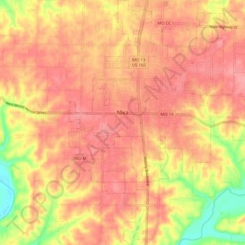
Name: Nixa topographic map, elevation, terrain.
Location: Nixa, Christian County, Missouri, 65714, United States (37.00122 -93.33579 37.08001 -93.25578)
Average elevation: 1,247 ft
Minimum elevation: 1,050 ft
Maximum elevation: 1,335 ft
Christian County trails, hiking, mountain biking, running and outdoor activities
Other topographic maps
Click on a map to view its topography, its elevation and its terrain.