
Make a donation
Gear up for your next adventure:
As an Amazon Associate, this site earns from qualifying purchases at no extra cost to you.
Ekurhuleni Ward 60 topographic map
Click on the map to display elevation.
Make a donation
Gear up for your next adventure:
As an Amazon Associate, this site earns from qualifying purchases at no extra cost to you.
About this map
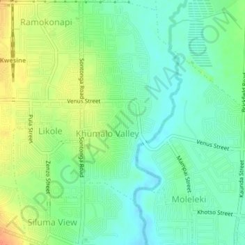
Name: Ekurhuleni Ward 60 topographic map, elevation, terrain.
Average elevation: 5,003 ft
Minimum elevation: 4,951 ft
Maximum elevation: 5,082 ft
Make a donation
Gear up for your next adventure:
As an Amazon Associate, this site earns from qualifying purchases at no extra cost to you.
Other topographic maps
Click on a map to view its topography, its elevation and its terrain.
Homestead Lake
South Africa > Gauteng > City of Ekurhuleni Metropolitan Municipality > Benoni
Average elevation: 5,410 ft
Etwatwa
South Africa > Gauteng > City of Ekurhuleni Metropolitan Municipality
Average elevation: 5,285 ft
Jukskei River
South Africa > Gauteng > City of Ekurhuleni Metropolitan Municipality
Average elevation: 5,302 ft
Brackenhurst Park
South Africa > Gauteng > City of Ekurhuleni Metropolitan Municipality > Alberton
Average elevation: 5,200 ft
Make a donation
Gear up for your next adventure:
As an Amazon Associate, this site earns from qualifying purchases at no extra cost to you.
Rynfield Dam
South Africa > Gauteng > City of Ekurhuleni Metropolitan Municipality
Average elevation: 5,348 ft
Germiston Lake
South Africa > Gauteng > City of Ekurhuleni Metropolitan Municipality > Germiston
Average elevation: 5,430 ft
Atlasvlei Park
South Africa > Gauteng > City of Ekurhuleni Metropolitan Municipality
Average elevation: 5,430 ft