
Make a donation
Gear up for your next adventure:
As an Amazon Associate, this site earns from qualifying purchases at no extra cost to you.
Moosehead Lake topographic map
Click on the map to display elevation.
Make a donation
Gear up for your next adventure:
As an Amazon Associate, this site earns from qualifying purchases at no extra cost to you.
About this map
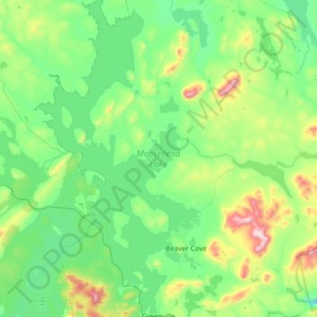
Name: Moosehead Lake topographic map, elevation, terrain.
Location: Moosehead Lake, Piscataquis County, Maine, United States (45.45894 -69.83310 45.88606 -69.50996)
Average elevation: 1,260 ft
Minimum elevation: 689 ft
Maximum elevation: 3,488 ft
Piscataquis County trails, hiking, mountain biking, running and outdoor activities
Make a donation
Gear up for your next adventure:
As an Amazon Associate, this site earns from qualifying purchases at no extra cost to you.
Other topographic maps
Click on a map to view its topography, its elevation and its terrain.
Make a donation
Gear up for your next adventure:
As an Amazon Associate, this site earns from qualifying purchases at no extra cost to you.