
Cornelius topographic map
Click on the map to display elevation.
About this map
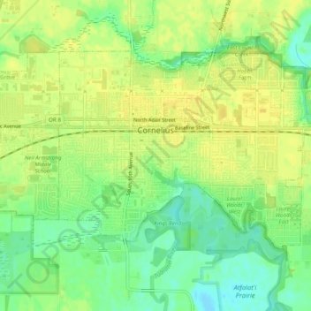
Name: Cornelius topographic map, elevation, terrain.
Location: Cornelius, Washington County, Oregon, United States (45.50556 -123.07077 45.52841 -123.02224)
Average elevation: 164 ft
Minimum elevation: 121 ft
Maximum elevation: 190 ft
Washington County trails, hiking, mountain biking, running and outdoor activities
Other topographic maps
Click on a map to view its topography, its elevation and its terrain.
Vern Galaway Memorial Park
United States > Oregon > Washington County > North Plains
Average elevation: 184 ft