Geolocate

Holon topographic map

Click on the map to display elevation.

About this map

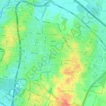
Name: Holon topographic map, elevation, terrain.

Location: Holon, Tel Aviv Subdistrict, Tel Aviv District, Israel (31.98872 34.75529 32.03867 34.81477)

Average elevation: 108 ft

Minimum elevation: 39 ft

Maximum elevation: 223 ft

Other topographic maps

Click on a map to view its topography, its elevation and its terrain.

Tel Aviv

Israel > Tel Aviv District > Tel Aviv

Average elevation: 82 ft

Gear up for your next adventure:

🔌Solar Panel Charger - Charge gear sustainably outdoors
🗃️Trail First Aid Kit - Essential kit for outdoor injuries and emergencies
🛏️Cold Weather Sleeping Bag - Warm sleeping bag for cold conditions
🪓Survival Multi‑Tool - Versatile tool for camp and trail tasks
🧣Merino Neck Gaiters - Multi-functional headwear for wind and sun protection

As an Amazon Associate, this site earns from qualifying purchases at no extra cost to you.