
Thank you for supporting this site ❤️
Make a donation
Make a donation
Gear up for your next adventure:
As an Amazon Associate, this site earns from qualifying purchases at no extra cost to you.
O Porriño topographic map
Click on the map to display elevation.
Thank you for supporting this site ❤️
Make a donation
Make a donation
Gear up for your next adventure:
As an Amazon Associate, this site earns from qualifying purchases at no extra cost to you.
About this map
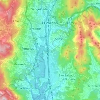
Name: O Porriño topographic map, elevation, terrain.
Location: O Porriño, Vigo, Pontevedra, Galicia, Spain (42.08832 -8.69895 42.18369 -8.57867)
Average elevation: 535 ft
Minimum elevation: 16 ft
Maximum elevation: 1,942 ft
Thank you for supporting this site ❤️
Make a donation
Make a donation
Gear up for your next adventure:
As an Amazon Associate, this site earns from qualifying purchases at no extra cost to you.