
Make a donation
Gear up for your next adventure:
As an Amazon Associate, this site earns from qualifying purchases at no extra cost to you.
Büchen topographic map
Click on the map to display elevation.
Make a donation
Gear up for your next adventure:
As an Amazon Associate, this site earns from qualifying purchases at no extra cost to you.
Büchen
Ab 1900 siedelten sich um den Bahnhof, der damals zur Gemeinde Pötrau mit 72 Einwohnern gehörte, immer mehr Menschen an und so wuchsen die weit auseinander liegenden Dörfer Nüssau, Pötrau und Büchen (-Dorf) zusammen. Wegen der sehr viel höheren Einwohnerzahl in Büchen-Bahnhof wurde der Zusatz weggelassen, dafür bekam das damalige Büchen den Zusatz „-Dorf“.
Make a donation
Gear up for your next adventure:
As an Amazon Associate, this site earns from qualifying purchases at no extra cost to you.
About this map
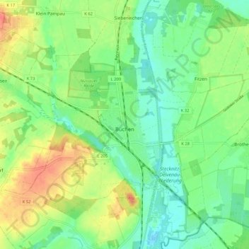
Name: Büchen topographic map, elevation, terrain.
Average elevation: 82 ft
Minimum elevation: 20 ft
Maximum elevation: 177 ft
Make a donation
Gear up for your next adventure:
As an Amazon Associate, this site earns from qualifying purchases at no extra cost to you.
Other topographic maps
Click on a map to view its topography, its elevation and its terrain.
Rothenhusen
Deutschland > Schleswig-Holstein > Kreis Herzogtum Lauenburg > Groß Sarau
Average elevation: 66 ft
Drüsen
Deutschland > Schleswig-Holstein > Kreis Herzogtum Lauenburg > Lehmrade
Average elevation: 131 ft
Make a donation
Gear up for your next adventure:
As an Amazon Associate, this site earns from qualifying purchases at no extra cost to you.
Dalbekschlucht
Deutschland > Schleswig-Holstein > Kreis Herzogtum Lauenburg > Börnsen
Average elevation: 131 ft