
Ash topographic map
Click on the map to display elevation.
About this map
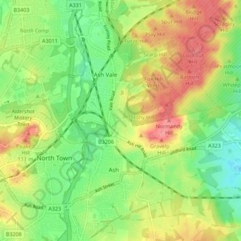
Name: Ash topographic map, elevation, terrain.
Location: Ash, Guildford, Surrey, England, United Kingdom (51.23532 -0.73852 51.28334 -0.69987)
Average elevation: 269 ft
Minimum elevation: 161 ft
Maximum elevation: 394 ft
Other topographic maps
Click on a map to view its topography, its elevation and its terrain.
Tillingbourne Trout Farm and Smokery
United Kingdom > England > Surrey > Guildford > Shere
Average elevation: 404 ft
Gunpowder Mills Fishery
United Kingdom > England > Surrey > Guildford > Chilworth
Average elevation: 276 ft