
Thank you for supporting this site ❤️
Make a donation
Make a donation
Gear up for your next adventure:
As an Amazon Associate, this site earns from qualifying purchases at no extra cost to you.
Alcaufar topographic map
Click on the map to display elevation.
Thank you for supporting this site ❤️
Make a donation
Make a donation
Gear up for your next adventure:
As an Amazon Associate, this site earns from qualifying purchases at no extra cost to you.
About this map
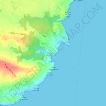
Name: Alcaufar topographic map, elevation, terrain.
Location: Alcaufar, San Luis, Menorca, Islas Baleares, 07713, España (39.80891 4.27555 39.84891 4.31555)
Average elevation: 56 ft
Minimum elevation: -3 ft
Maximum elevation: 246 ft
Thank you for supporting this site ❤️
Make a donation
Make a donation
Gear up for your next adventure:
As an Amazon Associate, this site earns from qualifying purchases at no extra cost to you.