
Apara topographic map
Click on the map to display elevation.
About this map
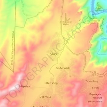
Name: Apara topographic map, elevation, terrain.
Average elevation: 3,950 ft
Minimum elevation: 2,185 ft
Maximum elevation: 5,259 ft
Other topographic maps
Click on a map to view its topography, its elevation and its terrain.
Blyde River Canyon Nature Reserve
South Africa > Mpumalanga > Ehlanzeni District Municipality > Thaba Chweu Local Municipality
The Mogologolo (1,794 m), Mariepskop (1,944 m) and Hebronberg (1,767 m) massifs are partially included in the reserve. Elevation varies from 560 m to 1,944 m above sea level. Its resort areas are F.H. Odendaal and Swadeni, the latter only accessible from Limpopo province. The area of approximately 29,000…
Average elevation: 3,412 ft
Lydenburg
South Africa > Mpumalanga > Ehlanzeni District Municipality > Thaba Chweu Local Municipality
Average elevation: 4,672 ft
Kwena Dam
South Africa > Mpumalanga > Ehlanzeni District Municipality > Thaba Chweu Local Municipality
Average elevation: 3,888 ft
Witklip Dam
South Africa > Mpumalanga > Ehlanzeni District Municipality > Thaba Chweu Local Municipality
Average elevation: 3,438 ft
Umgwenya
South Africa > Mpumalanga > Ehlanzeni District Municipality > Thaba Chweu Local Municipality
Average elevation: 3,970 ft
Lydenburg
South Africa > Mpumalanga > Ehlanzeni District Municipality > Thaba Chweu Local Municipality
Average elevation: 4,672 ft
Umgwenya
South Africa > Mpumalanga > Ehlanzeni District Municipality > Thaba Chweu Local Municipality
Average elevation: 3,973 ft
Kwena Dam
South Africa > Mpumalanga > Ehlanzeni District Municipality > Thaba Chweu Local Municipality
Average elevation: 3,888 ft
Lydenburg
South Africa > Mpumalanga > Ehlanzeni District Municipality > Thaba Chweu Local Municipality
Average elevation: 4,672 ft