
Make a donation
Gear up for your next adventure:
As an Amazon Associate, this site earns from qualifying purchases at no extra cost to you.
Leupegem topographic map
Click on the map to display elevation.
Make a donation
Gear up for your next adventure:
As an Amazon Associate, this site earns from qualifying purchases at no extra cost to you.
Leupegem
Leupegem ligt in Zandlemig Vlaanderen, aan de Schelde. Ook de Markebeek mondt te Leupegem uit in de Schelde. Ten noorden van de Markebeek zijn steile hellingen en deels bebost zijn. De hoogte varieert van ongeveer 20 meter tot ruim 80 meter. Leupegem is enigszins verstedelijkt en vastgebouwd aan Oudenaarde.
Make a donation
Gear up for your next adventure:
As an Amazon Associate, this site earns from qualifying purchases at no extra cost to you.
About this map
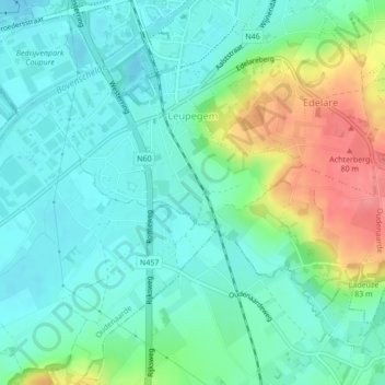
Name: Leupegem topographic map, elevation, terrain.
Location: Leupegem, Oudenaarde, Oost-Vlaanderen, Vlaanderen, België (50.81908 3.59527 50.83731 3.63345)
Average elevation: 92 ft
Minimum elevation: 16 ft
Maximum elevation: 282 ft
Make a donation
Gear up for your next adventure:
As an Amazon Associate, this site earns from qualifying purchases at no extra cost to you.