
Make a donation
Gear up for your next adventure:
As an Amazon Associate, this site earns from qualifying purchases at no extra cost to you.
Lago Rapel topographic map
Click on the map to display elevation.
Make a donation
Gear up for your next adventure:
As an Amazon Associate, this site earns from qualifying purchases at no extra cost to you.
About this map
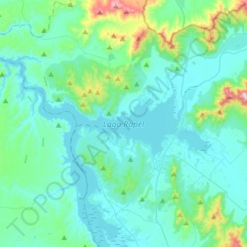
Name: Lago Rapel topographic map, elevation, terrain.
Average elevation: 597 ft
Minimum elevation: 325 ft
Maximum elevation: 2,283 ft
Make a donation
Gear up for your next adventure:
As an Amazon Associate, this site earns from qualifying purchases at no extra cost to you.
Other topographic maps
Click on a map to view its topography, its elevation and its terrain.
La Cebada
Chile > Región del Libertador General Bernardo O'Higgins > Provincia de Cachapoal > Las Cabras > La Cebada
Average elevation: 495 ft
Cerro Las Bandurrias
Chile > Región del Libertador General Bernardo O'Higgins > Provincia de Cachapoal > Las Cabras
Average elevation: 1,532 ft
Casa Blanca
Chile > Región del Libertador General Bernardo O'Higgins > Provincia de Cachapoal > Las Cabras > Casa Blanca
Average elevation: 771 ft
Unión Victoria
Chile > Región del Libertador General Bernardo O'Higgins > Provincia de Cachapoal > Las Cabras
Average elevation: 397 ft
Make a donation
Gear up for your next adventure:
As an Amazon Associate, this site earns from qualifying purchases at no extra cost to you.
El Carmen Río
Chile > Región del Libertador General Bernardo O'Higgins > Provincia de Cachapoal > Las Cabras > El Carmen
Average elevation: 400 ft
La Puntilla Poniente
Chile > Región del Libertador General Bernardo O'Higgins > Provincia de Cachapoal > Las Cabras
Average elevation: 410 ft