Geolocate

Conway topographic map

Click on the map to display elevation.

About this map

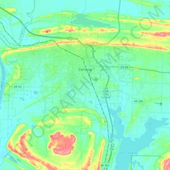
Name: Conway topographic map, elevation, terrain.

Location: Conway, Faulkner County, Arkansas, United States (34.99934 -92.58698 35.14652 -92.38147)

Average elevation: 335 ft

Minimum elevation: 253 ft

Maximum elevation: 620 ft

Faulkner County trails, hiking, mountain biking, running and outdoor activities

Other topographic maps

Click on a map to view its topography, its elevation and its terrain.

Round Mountain

United States > Arkansas > Faulkner County > Conway

Average elevation: 420 ft

Gear up for your next adventure:

🧭Compass with Lanyard - Easy‑carry compass for navigation
🧭Outdoor Navigation Book - Learn advanced navigation skills
🌧️Backpack Rain Cover - Keep gear dry in wet weather
🪶Thermal Camp Blanket - Extra warmth for cold nights
GPS Sports Watch - GPS watch for running, hiking and training

As an Amazon Associate, this site earns from qualifying purchases at no extra cost to you.