
Make a donation
Gear up for your next adventure:
As an Amazon Associate, this site earns from qualifying purchases at no extra cost to you.
Heeze topographic map
Click on the map to display elevation.
Make a donation
Gear up for your next adventure:
As an Amazon Associate, this site earns from qualifying purchases at no extra cost to you.
Heeze
Op de laatste zondag van augustus vindt de Brabantsedag plaats, die jaarlijks zo'n 30.000 bezoekers trekt. Het hoogtepunt is de theaterparade, een cultuurhistorische optocht die door de straten van het dorp trekt. Zestien wagenbouwersgroepen kiezen uit een overkoepelend thema een eigen thema, waarover ze een huizenhoge wagen ontwerpen en bouwen. Al vanaf het begin in 1958 hebben de thema’s een connectie met Brabant.
Make a donation
Gear up for your next adventure:
As an Amazon Associate, this site earns from qualifying purchases at no extra cost to you.
About this map
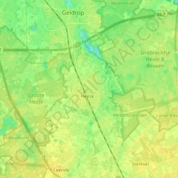
Name: Heeze topographic map, elevation, terrain.
Location: Heeze, Heeze-Leende, Noord-Brabant, Nederland (51.35064 5.50464 51.42246 5.63904)
Average elevation: 79 ft
Minimum elevation: 43 ft
Maximum elevation: 98 ft
Make a donation
Gear up for your next adventure:
As an Amazon Associate, this site earns from qualifying purchases at no extra cost to you.
Other topographic maps
Click on a map to view its topography, its elevation and its terrain.
Eindhoven
Nederland > Noord-Brabant > Eindhoven
Eindhoven telt meer dan 150 rijksmonumenten, waaronder een groot aantal historische bouwwerken. Het gebied de Bergen is nog in zijn oude staat, maar op andere plaatsen in de stad zijn bezienswaardige historische panden te bezoeken. Met name de industriële revolutie, die aanvankelijk door textiel-, sigaren- en…
Average elevation: 69 ft
Make a donation
Gear up for your next adventure:
As an Amazon Associate, this site earns from qualifying purchases at no extra cost to you.
Make a donation
Gear up for your next adventure:
As an Amazon Associate, this site earns from qualifying purchases at no extra cost to you.
Make a donation
Gear up for your next adventure:
As an Amazon Associate, this site earns from qualifying purchases at no extra cost to you.
Make a donation
Gear up for your next adventure:
As an Amazon Associate, this site earns from qualifying purchases at no extra cost to you.
Make a donation
Gear up for your next adventure:
As an Amazon Associate, this site earns from qualifying purchases at no extra cost to you.
Make a donation
Gear up for your next adventure:
As an Amazon Associate, this site earns from qualifying purchases at no extra cost to you.
Make a donation
Gear up for your next adventure:
As an Amazon Associate, this site earns from qualifying purchases at no extra cost to you.
Make a donation
Gear up for your next adventure:
As an Amazon Associate, this site earns from qualifying purchases at no extra cost to you.
Make a donation
Gear up for your next adventure:
As an Amazon Associate, this site earns from qualifying purchases at no extra cost to you.
Make a donation
Gear up for your next adventure:
As an Amazon Associate, this site earns from qualifying purchases at no extra cost to you.
Make a donation
Gear up for your next adventure:
As an Amazon Associate, this site earns from qualifying purchases at no extra cost to you.
Make a donation
Gear up for your next adventure:
As an Amazon Associate, this site earns from qualifying purchases at no extra cost to you.
Make a donation
Gear up for your next adventure:
As an Amazon Associate, this site earns from qualifying purchases at no extra cost to you.
Make a donation
Gear up for your next adventure:
As an Amazon Associate, this site earns from qualifying purchases at no extra cost to you.
Make a donation
Gear up for your next adventure:
As an Amazon Associate, this site earns from qualifying purchases at no extra cost to you.
Zevenbergen
Nederland > Noord-Brabant > Zevenbergen > Zevenbergen
In het begin van de 16e eeuw was Cornelis van Bergen weer begonnen met de inpoldering rond Zevenbergen. Daardoor kreeg de landbouw opnieuw een kans zich te ontwikkelen. Graan, boekweit, vlas en vooral ook meekrap waren producten van deze streek. De laatste bleef tot in de 19e eeuw een belangrijk rol vervullen…
Average elevation: 3 ft
Make a donation
Gear up for your next adventure:
As an Amazon Associate, this site earns from qualifying purchases at no extra cost to you.
's-Hertogenbosch
Nederland > Noord-Brabant > 's-Hertogenbosch
In figuurlijke zin is de stad een rooms-katholiek bolwerk, waarvan ook vandaag de dag nog alle kenmerken in de kunst en de kerken terug te vinden zijn. De Sint-Janskathedraal, het hoogtepunt van de late Brabantse gotiek is een van de meest karakteristieke gebouwen van de stad. Het is een kerkgebouw met de…
Average elevation: 23 ft
Nistelrode
Nederland > Noord-Brabant > Nistelrode > Nistelrode
In 1648 kwamen de katholieke kerken en kapellen in handen van de protestanten. De uitoefening van de katholieke godsdienst werd in de Meierij van 's-Hertogenbosch verboden. De Nistelrodense bevolking kerkte daarop met inwoners van Heeswijk en Dinther vanaf 1650 in een grenskerk te Bedaf, direct over de…
Average elevation: 39 ft
Make a donation
Gear up for your next adventure:
As an Amazon Associate, this site earns from qualifying purchases at no extra cost to you.
Make a donation
Gear up for your next adventure:
As an Amazon Associate, this site earns from qualifying purchases at no extra cost to you.
Make a donation
Gear up for your next adventure:
As an Amazon Associate, this site earns from qualifying purchases at no extra cost to you.
Make a donation
Gear up for your next adventure:
As an Amazon Associate, this site earns from qualifying purchases at no extra cost to you.
Make a donation
Gear up for your next adventure:
As an Amazon Associate, this site earns from qualifying purchases at no extra cost to you.
Make a donation
Gear up for your next adventure:
As an Amazon Associate, this site earns from qualifying purchases at no extra cost to you.
Make a donation
Gear up for your next adventure:
As an Amazon Associate, this site earns from qualifying purchases at no extra cost to you.
Make a donation
Gear up for your next adventure:
As an Amazon Associate, this site earns from qualifying purchases at no extra cost to you.
Make a donation
Gear up for your next adventure:
As an Amazon Associate, this site earns from qualifying purchases at no extra cost to you.