Khardung La topographic map
Interactive map
Click on the map to display elevation.
About this map
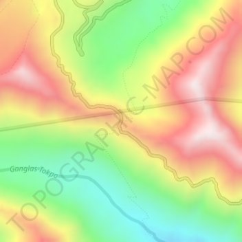
Name: Khardung La topographic map, elevation, terrain.
Location: Khardung La, Leh Tehsil, Leh district, Ladakh, India (34.27861 77.60458 34.27871 77.60468)
Average elevation: 17,178 ft
Minimum elevation: 15,961 ft
Maximum elevation: 18,465 ft
The elevation of Khardung La is 5,359 m (17,582 ft). Local summit signs and dozens of stores selling shirts in Leh incorrectly claim that its elevation is in the vicinity of 5,602 m (18,379 ft)} and that it is the world's highest motorable pass. But in 2013-2014, Chisumle-Demchok Road via Umling La (19,300 ft), which is one of the India-China Border Roads built as a part of Project Himank by BRO, surpassed Khardung La in elevation to become the world's highest motorable pass.
Other topographic maps
Click on a map to view its topography, its elevation and its terrain.
Basgo
India > Ladakh > Leh Tehsil
Basgo, Leh Tehsil, Leh District, Ladakh, India
Average elevation: 11,047 ft
Upshi
India > Ladakh > Leh Tehsil
Upshi, Leh Tehsil, Leh District, Ladakh, India
Average elevation: 11,765 ft
Leh
India > Ladakh > Leh Tehsil
Leh, Leh Tehsil, Leh District, Ladakh, India
Average elevation: 11,985 ft
Dungti
India > Ladakh > Leh Tehsil
Dungti, Leh Tehsil, Leh District, Ladakh, India
Average elevation: 14,045 ft
Mudh
India > Ladakh > Leh Tehsil
Mudh, Leh Tehsil, Leh District, Ladakh, 194404, India
Average elevation: 14,186 ft
Mahe
India > Ladakh > Leh Tehsil
Mahe, Leh Tehsil, Leh District, Ladakh, India
Average elevation: 14,446 ft
Nimo
India > Ladakh > Leh Tehsil
Nimo, Leh Tehsil, Leh District, Ladakh, India
Average elevation: 10,768 ft
Sakti
India > Ladakh > Leh Tehsil
Sakti, Leh Tehsil, Leh district, Ladakh, India
Average elevation: 12,605 ft
Pharka
India > Ladakh > Leh Tehsil > Spituk
Pharka, Spituk, Leh Tehsil, Leh district, Ladakh, India
Average elevation: 10,725 ft
Lato
India > Ladakh > Leh Tehsil
Lato, Leh Tehsil, Leh district, Ladakh, India
Average elevation: 14,003 ft
Kang Yatse 4 North
India > Ladakh > Leh Tehsil
Kang Yatse 4 North, Leh Tehsil, Leh district, Ladakh, India
Average elevation: 18,894 ft
Phyang
India > Ladakh > Leh Tehsil
Phyang, Leh Tehsil, Leh district, Ladakh, 194101, India
Average elevation: 12,277 ft
Chinese claimed Pangong Tso area
India > Ladakh > Leh Tehsil
Chinese claimed Pangong Tso area, Leh Tehsil, Leh district, Ladakh, India
Average elevation: 14,308 ft
Korzok Kangri
India > Ladakh > Leh Tehsil
Korzok Kangri, Leh Tehsil, Leh district, Ladakh, India
Average elevation: 18,488 ft
Chemre
India > Ladakh > Leh Tehsil > Chemre
Chemre, Leh Tehsil, Leh district, Ladakh, India
Average elevation: 12,175 ft
Shey
India > Ladakh > Leh Tehsil > Shey
Shey, Leh Tehsil, Leh district, Ladakh, 194201, India
Average elevation: 10,768 ft
Spituk
India > Ladakh > Leh Tehsil > Spituk
Spituk, Leh Tehsil, Leh district, Ladakh, India
Average elevation: 10,673 ft
Stok
India > Ladakh > Leh Tehsil
Stok, Leh Tehsil, Leh district, Ladakh, India
Average elevation: 11,745 ft
Tso Moriri
India > Ladakh > Leh Tehsil > Karzok
Tso Moriri, Karzok, Leh Tehsil, Leh district, Ladakh, India
Average elevation: 16,549 ft
Nyoma
India > Ladakh > Leh Tehsil
Nyoma, Leh Tehsil, Leh District, Ladakh, 194404, India
Average elevation: 13,976 ft