Geolocate

Tumbes topographic map

Click on the map to display elevation.

About this map

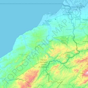
Name: Tumbes topographic map, elevation, terrain.

Location: Tumbes, Peru (-4.23190 -81.04392 -3.39226 -80.12640)

Average elevation: 846 ft

Minimum elevation: -13 ft

Maximum elevation: 6,598 ft

Gear up for your next adventure:

🪶Camp Gear Gift Set - Perfect gift bundle for outdoor fans
👖Convertible Hiking Pants - Versatile zip-off pants for changing altitudes and temperatures
🪄Magnetic Compass - Accurate compass for navigation
📚Navigation Handbooks - Master the art of reading topographic maps and using a compass
🧢Outdoor Hiking Hat - Sun protection hat for outdoor explorers

As an Amazon Associate, this site earns from qualifying purchases at no extra cost to you.