Geolocate

North Bend topographic map

Click on the map to display elevation.

About this map

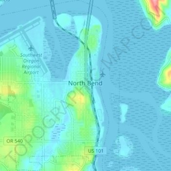
Name: North Bend topographic map, elevation, terrain.

Location: North Bend, Coos County, Oregon, United States (43.38389 -124.25952 43.42779 -124.21596)

Average elevation: 36 ft

Minimum elevation: -20 ft

Maximum elevation: 344 ft

Other topographic maps

Click on a map to view its topography, its elevation and its terrain.

Bandon

United States > Oregon > Coos County

Bandon, Coos County, Oregon, United States

Average elevation: 72 ft

Coos Bay

United States > Oregon > Coos County

Coos Bay, Coos County, Oregon, 97420, United States

Average elevation: 98 ft

Lakeside

United States > Oregon > Coos County

Lakeside, Coos County, Oregon, 97449, United States

Average elevation: 105 ft

Judge Hamilton County Park

United States > Oregon > Coos County

Judge Hamilton County Park, Coos County, Oregon, United States

Average elevation: 1,381 ft

Coquille

United States > Oregon > Coos County

Coquille, Coos County, Oregon, United States

Average elevation: 131 ft

Dora

United States > Oregon > Coos County

Dora, Coos County, Oregon, United States

Average elevation: 594 ft

Powers

United States > Oregon > Coos County

Powers, Coos County, Oregon, 97466, United States

Average elevation: 476 ft

Bunker Hill

United States > Oregon > Coos County

Bunker Hill, Coos County, Oregon, United States

Average elevation: 66 ft

Randolph

United States > Oregon > Coos County

Randolph, Coos County, Oregon, United States

Average elevation: 118 ft

Bay Park

United States > Oregon > Coos County

Bay Park, Coos County, Oregon, 870, United States

Average elevation: 89 ft

Broadbent

United States > Oregon > Coos County

Broadbent, Coos County, Oregon, 97414, United States

Average elevation: 223 ft

In order to remain free and to keep improving, this site uses cookies created by Google to compile visit statistics and display personalized advertisements.

How is the collected data used?