
Thank you for supporting this site ❤️
Make a donation
Make a donation
Gear up for your next adventure:
As an Amazon Associate, this site earns from qualifying purchases at no extra cost to you.
Pierrefit topographic map
Click on the map to display elevation.
Thank you for supporting this site ❤️
Make a donation
Make a donation
Gear up for your next adventure:
As an Amazon Associate, this site earns from qualifying purchases at no extra cost to you.
About this map
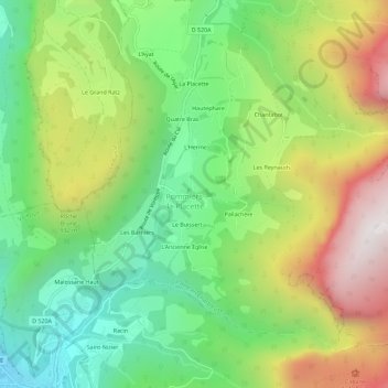
Name: Pierrefit topographic map, elevation, terrain.
Average elevation: 2,388 ft
Minimum elevation: 712 ft
Maximum elevation: 4,892 ft
Thank you for supporting this site ❤️
Make a donation
Make a donation
Gear up for your next adventure:
As an Amazon Associate, this site earns from qualifying purchases at no extra cost to you.
Other topographic maps
Click on a map to view its topography, its elevation and its terrain.
Saint-Julien-de-Raz
France > Auvergne-Rhône-Alpes > Isère > La Sure en Chartreuse
Average elevation: 1,969 ft
Pommiers-la-Placette
France > Auvergne-Rhône-Alpes > Isère > La Sure en Chartreuse
Average elevation: 3,451 ft