Geolocate

Bruce topographic map

Click on the map to display elevation.

About this map

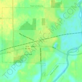
Name: Bruce topographic map, elevation, terrain.

Location: Bruce, Rusk County, Wisconsin, 54819, United States (45.44533 -91.29214 45.46852 -91.25252)

Average elevation: 1,096 ft

Minimum elevation: 1,060 ft

Maximum elevation: 1,129 ft

Rusk County trails, hiking, mountain biking, running and outdoor activities

Other topographic maps

Click on a map to view its topography, its elevation and its terrain.

Imalone

United States > Wisconsin > Rusk County > Imalone

Average elevation: 1,142 ft

Gear up for your next adventure:

🎒Outdoor Daypacks - Lightweight backpacks designed for carrying maps and essential gear
📚USA Hiking Guide Books - Top trail guides and map books
🦶Carbon Trekking Poles - Reduce knee impact on steep descents with ultra-light poles
🍳Camping Cook Set - Complete cookware for outdoor meals
🩹Survival Bandages - High‑quality bandages for emergencies

As an Amazon Associate, this site earns from qualifying purchases at no extra cost to you.