
Harmony topographic map
Click on the map to display elevation.
About this map
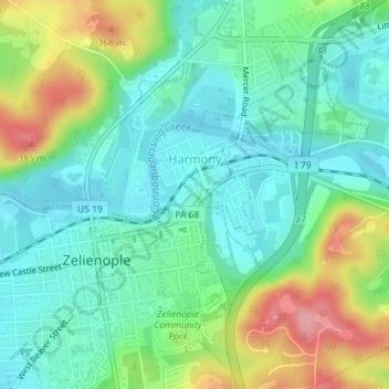
Name: Harmony topographic map, elevation, terrain.
Location: Harmony, Butler County, Pennsylvania, United States (40.79135 -80.13198 40.80913 -80.11217)
Average elevation: 1,010 ft
Minimum elevation: 889 ft
Maximum elevation: 1,280 ft
Butler County trails, hiking, mountain biking, running and outdoor activities
Other topographic maps
Click on a map to view its topography, its elevation and its terrain.
Greece City
United States > Pennsylvania > Butler County > Concord Township
Average elevation: 1,227 ft
Glade Mills
United States > Pennsylvania > Butler County > Middlesex Township
Average elevation: 1,178 ft
Bonnie Brook
United States > Pennsylvania > Butler County > Summit Township
Average elevation: 1,204 ft
Hilliards
United States > Pennsylvania > Butler County > Washington Township
Average elevation: 1,404 ft
Bonnie Brook
United States > Pennsylvania > Butler County > Summit Township
Average elevation: 1,204 ft
Butler Farm Show Lake
United States > Pennsylvania > Butler County > Meridian
Average elevation: 1,286 ft
Cunningham
United States > Pennsylvania > Butler County > Clinton Township
Average elevation: 1,106 ft