
Make a donation
Gear up for your next adventure:
As an Amazon Associate, this site earns from qualifying purchases at no extra cost to you.
San Fermo topographic map
Click on the map to display elevation.
Make a donation
Gear up for your next adventure:
As an Amazon Associate, this site earns from qualifying purchases at no extra cost to you.
About this map
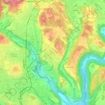
Name: San Fermo topographic map, elevation, terrain.
Location: San Fermo, Varese, Lombardia, 21056, Italia (45.81289 8.83059 45.85289 8.87059)
Average elevation: 1,296 ft
Minimum elevation: 997 ft
Maximum elevation: 1,654 ft
Make a donation
Gear up for your next adventure:
As an Amazon Associate, this site earns from qualifying purchases at no extra cost to you.
Other topographic maps
Click on a map to view its topography, its elevation and its terrain.
Campo dei Fiori
Italia > Lombardia > Varese > Varese > Santa Maria del Monte
Il Campo dei Fiori raggiunge un'altitudine di 1.227 m s.l.m. ed è una dorsale composta da numerose punte. Procedendo da ovest verso est si incontrano le vette.
Average elevation: 2,398 ft