
Make a donation
Gear up for your next adventure:
As an Amazon Associate, this site earns from qualifying purchases at no extra cost to you.
Labiodh Medjadja topographic map
Click on the map to display elevation.
Make a donation
Gear up for your next adventure:
As an Amazon Associate, this site earns from qualifying purchases at no extra cost to you.
Labiodh Medjadja
Le vieux village de Medjadja est situé 4 km au nord au cœur du massif à 400 mètres d'altitude. Il abrite la zaouia de Sidi M'hamed Ben Ali, petit-fils de sidi Yedder el Ouattassi (des beni Ouattas, tribu berbère zénète régnant au Maroc), ancêtre de la tribu des chorfas des Medjadjas d'où descendent les principales familles de Chlef.
Make a donation
Gear up for your next adventure:
As an Amazon Associate, this site earns from qualifying purchases at no extra cost to you.
About this map
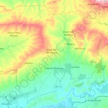
Name: Labiodh Medjadja topographic map, elevation, terrain.
Location: Labiodh Medjadja, Daïra Ouled Fares, Chlef, Algérie (36.20728 1.31994 36.32861 1.48585)
Average elevation: 1,119 ft
Minimum elevation: 315 ft
Maximum elevation: 2,641 ft
Make a donation
Gear up for your next adventure:
As an Amazon Associate, this site earns from qualifying purchases at no extra cost to you.