Geolocate

Cornelia topographic map

Click on the map to display elevation.

About this map

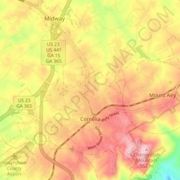
Name: Cornelia topographic map, elevation, terrain.

Location: Cornelia, Habersham County, Georgia, United States (34.49307 -83.55802 34.54719 -83.50212)

Average elevation: 1,463 ft

Minimum elevation: 1,001 ft

Maximum elevation: 1,785 ft

Habersham County trails, hiking, mountain biking, running and outdoor activities

Other topographic maps

Click on a map to view its topography, its elevation and its terrain.

Aerial

United States > Georgia > Habersham County

Average elevation: 1,476 ft

Pardue Mill

United States > Georgia > Habersham County

Average elevation: 1,355 ft

Gear up for your next adventure:

🔭Compact Binoculars - HD vision for scouting terrain and identifying distant landmarks
🌎3D Topographic Globes - Raised relief globes for a tactile understanding of geography
📡GPS Antenna Upgrade - Enhance GPS reception in remote terrain
🔭Telescopic Hiking Pole - Adjustable pole for hiking stability
🥾Men's Hiking Boots - Durable, waterproof footwear for rugged terrain and steep inclines

As an Amazon Associate, this site earns from qualifying purchases at no extra cost to you.