Geolocate
👉 Easily get elevation data in JSON, GeoTIFF and KML formats using Elevation API
Thank you for supporting this site ❤️
Make a donation

Alachua topographic map

Click on the map to display elevation.

About this map

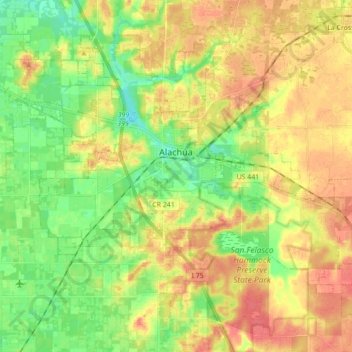
Name: Alachua topographic map, elevation, terrain.

Location: Alachua, Alachua County, Florida, United States (29.71842 -82.55577 29.84002 -82.38163)

Average elevation: 128 ft

Minimum elevation: 43 ft

Maximum elevation: 207 ft

Alachua County trails, hiking, mountain biking, running and outdoor activities

Other topographic maps

Click on a map to view its topography, its elevation and its terrain.

Earleton

United States > Florida > Alachua County

Average elevation: 151 ft

Island Grove

United States > Florida > Alachua County

Average elevation: 59 ft

Lakeview Estates

United States > Florida > Alachua County

Average elevation: 115 ft

Misty Oaks

United States > Florida > Alachua County

Average elevation: 69 ft

Bland

United States > Florida > Alachua County

Average elevation: 144 ft

Archer

United States > Florida > Alachua County > Archer

Average elevation: 82 ft

Gear up for your next adventure:

🔦LED Headlamp - Bright and durable LED headlamp for night navigation
📻Weather Alert Radios - Stay informed of storm risks while off-the-grid
📱Heavy-Duty Phone Cases - Drop-proof and waterproof protection for outdoor navigation
🏥Hiking First Aid Kits - Comprehensive medical kits for remote trail injuries
📚Navigation Handbooks - Master the art of reading topographic maps and using a compass

As an Amazon Associate, this site earns from qualifying purchases at no extra cost to you.