
Make a donation
Gear up for your next adventure:
As an Amazon Associate, this site earns from qualifying purchases at no extra cost to you.
Padrón topographic map
Click on the map to display elevation.
Make a donation
Gear up for your next adventure:
As an Amazon Associate, this site earns from qualifying purchases at no extra cost to you.
Padrón
El relieve del municipio está definido por los valles de los ríos Sar y Ulla. El río Sar procede de Rois, con quien hace límite inicialmente hasta adentrarse en el concejo y finalmente desembocar en el río Ulla, el cual a su vez hace de límite con la provincia de Pontevedra antes de adentrarse en el territorio y salir del mismo haciendo de límite con Puentecesures, rumbo a la ría de Arosa. Hacia el norte y el noreste se encuentran las zonas más montuosas, destacando el monte Outeiro da Meda (447 m). La altitud oscila entre los 447 m (Outeiro da Meda) y los 3 m en la desembocadura del Sar en el Ulla. La capital del concejo se alza a 5 m sobre el nivel del mar.
Make a donation
Gear up for your next adventure:
As an Amazon Associate, this site earns from qualifying purchases at no extra cost to you.
About this map
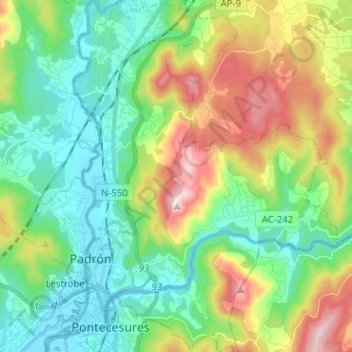
Name: Padrón topographic map, elevation, terrain.
Location: Padrón, Sar, La Coruña, Galicia, España (42.71224 -8.68611 42.80745 -8.57135)
Average elevation: 456 ft
Minimum elevation: -3 ft
Maximum elevation: 1,427 ft
Make a donation
Gear up for your next adventure:
As an Amazon Associate, this site earns from qualifying purchases at no extra cost to you.
Other topographic maps
Click on a map to view its topography, its elevation and its terrain.
Make a donation
Gear up for your next adventure:
As an Amazon Associate, this site earns from qualifying purchases at no extra cost to you.
Make a donation
Gear up for your next adventure:
As an Amazon Associate, this site earns from qualifying purchases at no extra cost to you.
Make a donation
Gear up for your next adventure:
As an Amazon Associate, this site earns from qualifying purchases at no extra cost to you.