Geolocate

Prague topographic map

Click on the map to display elevation.

About this map

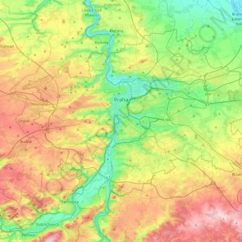
Name: Prague topographic map, elevation, terrain.

Location: Prague, obvod Praha 4, Capital City of Prague, Prague, Czechia (49.94190 14.22444 50.17743 14.70679)

Average elevation: 984 ft

Minimum elevation: 548 ft

Maximum elevation: 1,667 ft

Other topographic maps

Click on a map to view its topography, its elevation and its terrain.

White Mountain

Czechia > Prague > Capital City of Prague

Average elevation: 1,135 ft

Gear up for your next adventure:

🧢Outdoor Hiking Hat - Sun protection hat for outdoor explorers
🛶Inflatable Kayak - Portable kayak for rivers, lakes, and expeditions
🛌Ultralight Sleeping Bags - Compact down bags for cold nights in the wilderness
🛠️Outdoor Gear Repair Kit - Essential tools to fix gear on the trail
🔪Outdoor Multitools - Essential survival tools for gear repair and field use

As an Amazon Associate, this site earns from qualifying purchases at no extra cost to you.