
Pulau Kobroor topographic map
Interactive map
Click on the map to display elevation.
About this map
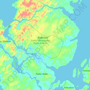
Name: Pulau Kobroor topographic map, elevation, terrain.
Location: Pulau Kobroor, Maluku, Indonesia (-6.52000 134.21333 -5.88000 134.85333)
Average elevation: 43 ft
Minimum elevation: -20 ft
Maximum elevation: 266 ft
Other topographic maps
Click on a map to view its topography, its elevation and its terrain.
Aroa
Indonesia > Maluku > Seram Bagian Timur
Aroa, Seram Bagian Timur, Maluku, Indonesia
Average elevation: 69 ft