
Make a donation
Gear up for your next adventure:
As an Amazon Associate, this site earns from qualifying purchases at no extra cost to you.
Lake Urmia topographic map
Click on the map to display elevation.
Make a donation
Gear up for your next adventure:
As an Amazon Associate, this site earns from qualifying purchases at no extra cost to you.
About this map
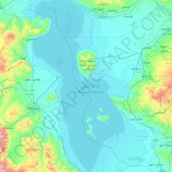
Name: Lake Urmia topographic map, elevation, terrain.
Location: Lake Urmia, East Azerbaijan Province, Iran (37.13316 45.05151 38.24211 45.80737)
Average elevation: 4,738 ft
Minimum elevation: 4,147 ft
Maximum elevation: 11,230 ft
Make a donation
Gear up for your next adventure:
As an Amazon Associate, this site earns from qualifying purchases at no extra cost to you.
Other topographic maps
Click on a map to view its topography, its elevation and its terrain.
خانقاه دیزمار
Iran > East Azerbaijan Province > Khoda Afarin County > دهستان دیزمارشرقی
Average elevation: 4,452 ft
Make a donation
Gear up for your next adventure:
As an Amazon Associate, this site earns from qualifying purchases at no extra cost to you.
Kamal
Iran > East Azerbaijan Province > Bostanabad County > دهستان شبلی
Sahand is one of the highest mountains in Iranian Azerbaijan, in addition to being an important dormant volcano in the country. The Sahand mountains are directly south of Tabriz, the highest peak of which is Kamal at an elevation of 3,707 m (12,162 ft). Approximately 17 peaks can be accounted for as being over…
Average elevation: 10,942 ft
Maragheh
Iran > East Azerbaijan Province > Maragheh County > Maragheh City
Average elevation: 4,941 ft
Make a donation
Gear up for your next adventure:
As an Amazon Associate, this site earns from qualifying purchases at no extra cost to you.
Shabistar
Iran > East Azerbaijan Province > Shabestar County > دهستان گونی شرقی
Average elevation: 4,754 ft
کلاسور
Iran > East Azerbaijan Province > Kaleybar County > دهستان میشه پاره
Average elevation: 5,719 ft
Make a donation
Gear up for your next adventure:
As an Amazon Associate, this site earns from qualifying purchases at no extra cost to you.
Make a donation
Gear up for your next adventure:
As an Amazon Associate, this site earns from qualifying purchases at no extra cost to you.
Hashtrud
Iran > East Azerbaijan Province > Hashtrud County > دهستان قرانقو
Average elevation: 5,545 ft
Make a donation
Gear up for your next adventure:
As an Amazon Associate, this site earns from qualifying purchases at no extra cost to you.
Kaleybar
Iran > East Azerbaijan Province > Kaleybar County > دهستان ییلاق
The relatively well preserved Babak Castle at an altitude of 2300 m is located is located some 3 km of the town. This Sasanid era fortress is named after the ninth century Iranian resistance leader, Babak Khorramdin., who resisted Arab armies until year 839.
Average elevation: 4,780 ft
Varziqan
Iran > East Azerbaijan Province > Varzaqan County > دهستان ازومدل جنوبی
Average elevation: 5,623 ft
Duzduzan
Iran > East Azerbaijan Province > Sarab County > دهستان شربیان
Duzduzan is located in the mountains of Arasbaran in north-western Iran on the highway between Ardabil and Tabriz. Although not on the river it is within the drainage basin of the Aji Chay. Because of its high elevation it has a climate that is generally cold and rainy. The city is 15 km by road east of the…
Average elevation: 5,486 ft
Make a donation
Gear up for your next adventure:
As an Amazon Associate, this site earns from qualifying purchases at no extra cost to you.
Sahand
Iran > East Azerbaijan Province > Bostanabad County > دهستان سهندآباد
Sahand is one of the highest mountains in Iranian Azerbaijan, in addition to being an important dormant volcano in the country. The Sahand mountains are directly south of Tabriz, the highest peak of which is Kamal at an elevation of 3,707 m (12,162 ft). Approximately 17 peaks can be accounted for as being over…
Average elevation: 10,230 ft
Beynaq, Razavi Khorasan
Iran > East Azerbaijan Province > Ahar County > دهستان اوچ هاچا > Beynaq, Razavi Khorasan
Average elevation: 5,246 ft
Make a donation
Gear up for your next adventure:
As an Amazon Associate, this site earns from qualifying purchases at no extra cost to you.
Karameh
Iran > East Azerbaijan Province > Mianeh County > دهستان کله بوزشرقی > Karameh
Average elevation: 4,029 ft
روستای ایستگاه هشترود
Iran > East Azerbaijan Province > Hashtrud County > دهستان نظرکهریزی
Average elevation: 5,377 ft
Make a donation
Gear up for your next adventure:
As an Amazon Associate, this site earns from qualifying purchases at no extra cost to you.