
Make a donation
Gear up for your next adventure:
As an Amazon Associate, this site earns from qualifying purchases at no extra cost to you.
Dunbar Township topographic map
Click on the map to display elevation.
Make a donation
Gear up for your next adventure:
As an Amazon Associate, this site earns from qualifying purchases at no extra cost to you.
About this map
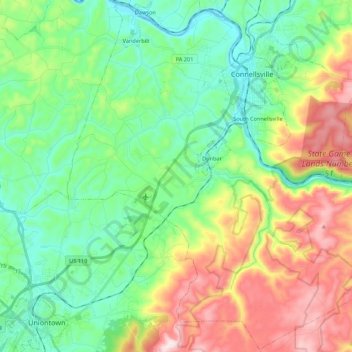
Name: Dunbar Township topographic map, elevation, terrain.
Location: Dunbar Township, Fayette County, Pennsylvania, United States (39.88737 -79.70391 40.05153 -79.48635)
Average elevation: 1,371 ft
Minimum elevation: 830 ft
Maximum elevation: 2,464 ft
Fayette County trails, hiking, mountain biking, running and outdoor activities
Make a donation
Gear up for your next adventure:
As an Amazon Associate, this site earns from qualifying purchases at no extra cost to you.
Other topographic maps
Click on a map to view its topography, its elevation and its terrain.
Normalville
United States > Pennsylvania > Fayette County > Springfield Township
Average elevation: 1,594 ft
Chalkhill
United States > Pennsylvania > Fayette County > Wharton Township
Average elevation: 2,044 ft
Arnold City
United States > Pennsylvania > Fayette County > Washington Township
Average elevation: 994 ft
Make a donation
Gear up for your next adventure:
As an Amazon Associate, this site earns from qualifying purchases at no extra cost to you.
Bear Rocks
United States > Pennsylvania > Fayette County > Bullskin Township
Average elevation: 1,873 ft
Farmington
United States > Pennsylvania > Fayette County > Wharton Township
Average elevation: 1,906 ft
East Fredricktown
United States > Pennsylvania > Fayette County > Luzerne Township
Average elevation: 991 ft
Farmington
United States > Pennsylvania > Fayette County > Wharton Township
Average elevation: 1,906 ft
Make a donation
Gear up for your next adventure:
As an Amazon Associate, this site earns from qualifying purchases at no extra cost to you.
New Salem
United States > Pennsylvania > Fayette County > Menallen Township
Average elevation: 1,086 ft
Bear Rocks
United States > Pennsylvania > Fayette County > Bullskin Township
Average elevation: 1,873 ft
Chestnut Ridge
United States > Pennsylvania > Fayette County > Redstone Township
Average elevation: 1,129 ft
Buffington
United States > Pennsylvania > Fayette County > Menallen Township
Average elevation: 1,086 ft
Make a donation
Gear up for your next adventure:
As an Amazon Associate, this site earns from qualifying purchases at no extra cost to you.
Griffin
United States > Pennsylvania > Fayette County > Nicholson Township
Average elevation: 1,040 ft
Brier Hill
United States > Pennsylvania > Fayette County > Redstone Township
Average elevation: 1,135 ft
Normalville
United States > Pennsylvania > Fayette County > Springfield Township
Average elevation: 1,594 ft
Make a donation
Gear up for your next adventure:
As an Amazon Associate, this site earns from qualifying purchases at no extra cost to you.
Mill Run
United States > Pennsylvania > Fayette County > Springfield Township
Average elevation: 1,581 ft