
Make a donation
Gear up for your next adventure:
As an Amazon Associate, this site earns from qualifying purchases at no extra cost to you.
Ellerbe topographic map
Click on the map to display elevation.
Make a donation
Gear up for your next adventure:
As an Amazon Associate, this site earns from qualifying purchases at no extra cost to you.
About this map
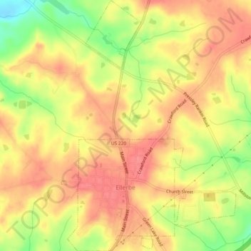
Name: Ellerbe topographic map, elevation, terrain.
Location: Ellerbe, Richmond County, North Carolina, United States (35.06171 -79.77320 35.09932 -79.74119)
Average elevation: 476 ft
Minimum elevation: 322 ft
Maximum elevation: 561 ft
Richmond County trails, hiking, mountain biking, running and outdoor activities
Make a donation
Gear up for your next adventure:
As an Amazon Associate, this site earns from qualifying purchases at no extra cost to you.
Other topographic maps
Click on a map to view its topography, its elevation and its terrain.
Maplewood
United States > North Carolina > Richmond County > Rockingham > East Rockingham
Average elevation: 272 ft
Oak Ridge Park
United States > North Carolina > Richmond County > East Rockingham
Average elevation: 279 ft
Make a donation
Gear up for your next adventure:
As an Amazon Associate, this site earns from qualifying purchases at no extra cost to you.
Maplewood
United States > North Carolina > Richmond County > Rockingham > Maplewood
Average elevation: 272 ft