
Flattach topographic map
Click on the map to display elevation.
About this map
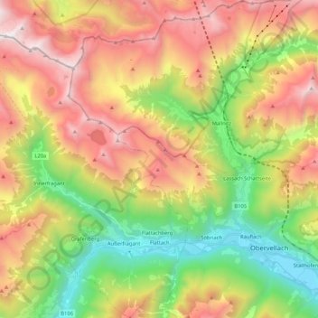
Name: Flattach topographic map, elevation, terrain.
Location: Flattach, Bezirk Spittal an der Drau, Carinthia, 9831, Austria (46.90132 12.98328 47.04387 13.14851)
Average elevation: 5,636 ft
Minimum elevation: 2,156 ft
Maximum elevation: 9,813 ft
Other topographic maps
Click on a map to view its topography, its elevation and its terrain.
Seebach
Austria > Carinthia > Bezirk Spittal an der Drau > Seeboden am Millstätter See
Average elevation: 2,146 ft
Innerkrems
Austria > Carinthia > Bezirk Spittal an der Drau > Krems in Kärnten
Average elevation: 5,942 ft